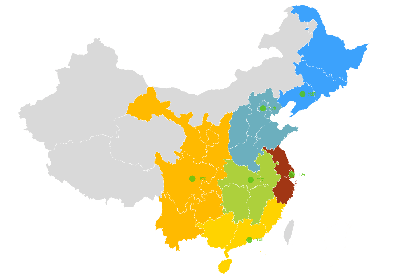
日常項目中經常會用到百度地圖或者echarts圖標展示,今天給大家展示的是如何在react開發項目中使用百度echars的地圖展示,把中國地圖分為東北大區、華東大區、華南大區、華西大區、華中大區以及華北大區並用顏色標識方便識別。 最終展示效果如下: 我是直接用的react官方提供的create-re ...
日常項目中經常會用到百度地圖或者echarts圖標展示,今天給大家展示的是如何在react開發項目中使用百度echars的地圖展示,把中國地圖分為東北大區、華東大區、華南大區、華西大區、華中大區以及華北大區並用顏色標識方便識別。
最終展示效果如下:

我是直接用的react官方提供的create-react-app快速構建開發環境,之後就是cnpm install --save echarts 安裝echarts依賴了。
在項目中引入echarts以及中國地圖數據,並引入模擬的大區地圖數據。
import echarts from 'echarts';
import 'echarts/map/js/china';
import geoJson from 'echarts/map/json/china.json';
import {geoCoordMap,provienceData} from "./geo";
geo.js是模擬的大區地圖數據,由於現在echarts地圖數據線上生成工具不能使用,為我們的開髮帶來許多不便,但我們仍能從以前的開發列子中找到生成方法,具體推薦大家觀看官方社區地圖實例: http://gallery.echartsjs.com/explore.html#charts=map~sort=rank~timeframe=all~author=all 剛開始看echarts也被裡面的各種配置參數所迷糊,但寫了幾遍後不難理解地圖是如何構建的,最主要的是在setOption裡面的option參數,其中尤其series配置參數最為重要,根據需要展示的地圖,把地圖分為map、scatter兩類,在分別對兩個參數進行配置修改,具體的實現是在initalECharts方法裡面,併在componentDidMount生命周期中調用:
    componentDidMount() {
        this.initalECharts();
    }
    initalECharts() {
        const data = [
            {name: '上海', area: '華東大區', type: 'areaCenterCity'},
            {name: '深圳', area: '華南大區', type: 'areaCenterCity'},
            {name: '成都', area: '華西大區', type: 'areaCenterCity'},
            {name: '北京', area: '華北大區', type: 'areaCenterCity'},
            {name: '武漢', area: '華中大區', type: 'areaCenterCity'},
            {name: '沈陽', area: '東北大區', type: 'areaCenterCity'},
        ];
        echarts.registerMap('zhongguo', geoJson);
        for(let item of provienceData){
            if(item.area === '東北大區'){
                item.itemStyle = {
                    normal: {
                        areaColor: "#3CA2FC",
                    },
                    emphasis: {
                        areaColor: "#3CA2FC",
                    }
                }
            }else if(item.area === '華北大區'){
                item.itemStyle = {
                    normal: {
                        areaColor: "#6CAFBE",
                    },
                    emphasis: {
                        areaColor: "#6CAFBE",
                    }
                }
            }else if(item.area === '華中大區'){
                item.itemStyle = {
                    normal: {
                        areaColor: "#ADD03C",
                    },
                    emphasis: {
                        areaColor: "#ADD03C",
                    }
                }
            }else if(item.area === '華東大區'){
                item.itemStyle = {
                    normal: {
                        areaColor: "#A13614",
                    },
                    emphasis: {
                        areaColor: "#A13614",
                    }
                }
            }else if(item.area === '華西大區'){
                item.itemStyle = {
                    normal: {
                        areaColor: "#FFBA00",
                    },
                    emphasis: {
                        areaColor: "#FFBA00",
                    }
                }
            }else if(item.area === '華南大區'){
                item.itemStyle = {
                    normal: {
                        areaColor: "#FFD300",
                    },
                    emphasis: {
                        areaColor: "#FFD300",
                    }
                }
                }else if(item.area === '南海諸島'){
                  item.itemStyle = {
                    normal: {
                      borderColor: '#fff',//區域邊框顏色
                      areaColor:"#fff",//區域顏色
                    },
                    emphasis: {
                      show: false,
                      // borderColor: '#fff',
                      // areaColor:"#fff",
                    }
                  }
            }else{
                item.itemStyle = {
                    normal: {
                        areaColor: "#D9D9D9",
                    },
                    emphasis: {
                        areaColor: "#D9D9D9",
                    }
                }
            }
        }
        const myChart = echarts.init(document.getElementById('mainMap'));
        myChart.setOption({
                tooltip: {
                    show: false,       //不顯示提示標簽
                    formatter: '{b}',      //提示標簽格式
                    backgroundColor:"#ff7f50",//提示標簽背景顏色
                    textStyle:{color:"#fff"} //提示標簽字體顏色
                },
                grid: {
                    left: '10%',
                    right: '10%',
                    top: '10%',
                    bottom: '10%',
                    containLabel: true
                },
                geo: {
                    map: 'china',
                    roam: false,
                    zoom: 1.2,
                    tooltip: {
                        show: false,       //不顯示提示標簽
                    },
                    label: {
                        normal: {
                            show: false,//顯示省份標簽
                            textStyle:{color:"#c71585"}//省份標簽字體顏色
                        },
                        emphasis: {//對應的滑鼠懸浮效果
                            show: false,
                            textStyle:{color:"#800080"}
                        }
                    },
                    itemStyle: {
                        normal: {
                            borderWidth: .5,//區域邊框寬度
                            borderColor: '#fff',//區域邊框顏色
                            areaColor:"#ffefd5",//區域顏色
                            label:{show:false}
                        },
                        emphasis: {
                            show: false,
                            borderWidth: .5,
                            borderColor: '#4b0082',
                            areaColor: "#ffdead",
                        }
                    },
                },
                series: [
                    {
                        type: 'scatter',
                        coordinateSystem: 'geo',
                        data: this.convertData(data),
                        symbolSize: 20,
                        symbolRotate: 35,
                        label: {
                            normal: {
                                formatter: '{b}',
                                position: 'right',
                                show: true
                            },
                            emphasis: {
                                show: false
                            }
                        },
                        tooltip: {
                            show: false,       //不顯示提示標簽
                            formatter: '{c}',      //提示標簽格式
                            backgroundColor: "#fff",//提示標簽背景顏色
                            borderColor: '#ccc',
                            borderWidth: .5,
                            textStyle:{color:"#000"} //提示標簽字體顏色
                        },
                        itemStyle: {
                            normal: {
                                color: '#57c610'
                            }
                        }
                    },
                    {
                        type: 'map',
                        mapType: 'china',
                        roam: false,
                        zoom: 1.2,
                        tooltip: {
                            show: false,       //不顯示提示標簽
                        },
                        label: {
                            normal: {
                                show: false    //顯示省份標簽
                            },
                            emphasis: {
                                show: false,
                            }
                        },
                        itemStyle: {
                            normal: {
                                borderWidth: .5,      //區域邊框寬度
                                borderColor: '#fff',  //區域邊框顏色
                                label:{show:false}
                            },
                            emphasis: {
                                show: false,
                            }
                        },
                        // geoIndex: 0,
                        // tooltip: {show: false},
                        data: provienceData
                    }
                ],
        })
    }
    convertData(data) {
        var res = [];
        for (var i = 0; i < data.length; i++) {
            var geoCoord = geoCoordMap[data[i].name];
            if (geoCoord) {
                res.push({
                    name: data[i].name,
                    value: geoCoord.concat(data[i].area),
                    area: data[i].area,
                    type: data[i].type,
                });
            }
        }
        console.log(res);
        return res;
    }
代碼我放在了碼雲裡面:
https://gitee.com/jianrun/echartsmap.git


