
首先註冊高德成為開發者(打開高德地圖,點擊底部的開發者平臺),創建應用,按照要求填寫相應信息 網站:http://lbs.amap.com/api/android-sdk/guide/create-project/get-key 途中包含了發佈版的SHA1安全碼和測試版SHA1安全碼,兩者的值可以看 ...
首先註冊高德成為開發者(打開高德地圖,點擊底部的開發者平臺),創建應用,按照要求填寫相應信息
網站:http://lbs.amap.com/api/android-sdk/guide/create-project/get-key
途中包含了發佈版的SHA1安全碼和測試版SHA1安全碼,兩者的值可以看
照做就一定會獲取的。
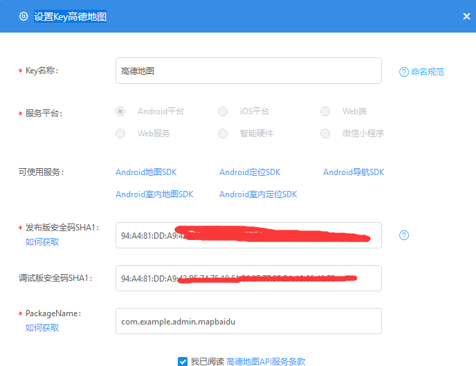
這裡我講發佈版和調試版都用的relase版本的sha1
之後再去下載相應的Jar包,這裡我用的是
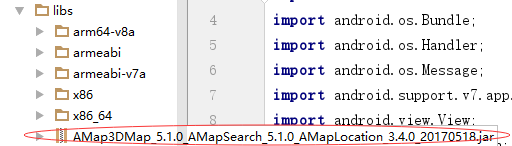 3D地圖的jar包
註意:2D地圖的jar包,與3D地圖的jar包因為介面有一樣的,導致衝突無法使用。
在jnilibs下放入一下文件

因為有些人的android studio無法顯示,但又不報錯(我就這樣)。你就需要將以上紅圈類容放入libs,才能顯示
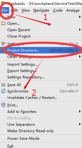
之後在
將導入的jar包添加到類包;
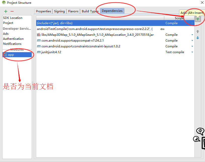
選擇 ,找到於自己名字一樣的Jar,添加就可以了。之後檢查在build.gradle 是否添加了以下類容
compile files('libs/AMap3DMap_5.1.0_AMapSearch_5.1.0_AMapLocation_3.4.0_20170518.jar')
    compile 'com.android.support:appcompat-v7:24.2.1'
    compile 'com.android.support.constraint:constraint-layout:1.0.2'
    testCompile 'junit:junit:4.12'
並且設置jar包的位置為libs
dependencies {
    compile fileTree(include: ['*.jar'], dir: 'libs')
    androidTestCompile('com.android.support.test.espresso:espresso-core:2.2.2', {
        exclude group: 'com.android.support', module: 'support-annotations'
    })
在androidManifest.xml中添加自己的添加許可權
<!-- 用於進行網路定位 -->
    <uses-permission android:name="android.permission.ACCESS_COARSE_LOCATION" />
    <!-- 用於訪問GPS定位 -->
    <uses-permission android:name="android.permission.ACCESS_FINE_LOCATION" />
    <!-- 用於獲取運營商信息,用於支持提供運營商信息相關的介面 -->
    <uses-permission android:name="android.permission.ACCESS_NETWORK_STATE" />
    <!-- 用於訪問wifi網路信息,wifi信息會用於進行網路定位 -->
    <uses-permission android:name="android.permission.ACCESS_WIFI_STATE" />
    <!-- 用於獲取wifi的獲取許可權,wifi信息會用來進行網路定位 -->
    <uses-permission android:name="android.permission.CHANGE_WIFI_STATE" />
    <!-- 用於訪問網路,網路定位需要上網 -->
    <uses-permission android:name="android.permission.INTERNET" />
    <!-- 用於讀取手機當前的狀態 -->
    <uses-permission android:name="android.permission.READ_PHONE_STATE" />
    <!-- 用於寫入緩存數據到擴展存儲卡 -->
    <uses-permission android:name="android.permission.WRITE_EXTERNAL_STORAGE" />
    <!-- 用於申請調用A-GPS模塊 -->
    <uses-permission android:name="android.permission.ACCESS_LOCATION_EXTRA_COMMANDS" />
    <!-- 用於申請獲取藍牙信息進行室內定位 -->
    <uses-permission android:name="android.permission.BLUETOOTH" />
    <uses-permission android:name="android.permission.BLUETOOTH_ADMIN" />
添加自己的key
<meta-data
                android:name="com.amap.api.v2.apikey"
                android:value="你的key" />
添加定位方法
<service android:name="com.amap.api.location.APSService" />
在Activity_main.xml中添加
<TextView
        android:layout_width="match_parent"
        android:layout_height="wrap_content"
        android:id="@+id/text1"/>
<com.amap.api.maps.MapView
            android:layout_width="fill_parent"
            android:layout_height="fill_parent"
            android:id="@+id/map">
        </com.amap.api.maps.MapView>
在MainActivty的主代碼
public class MainActivity extends AppCompatActivity implements AMapLocationListener,GeocodeSearch.OnGeocodeSearchListener {

    private Button button;
    private AMapLocationClient locationClient = null;
    private AMapLocationClientOption locationOption = null;
    private TextView textView;
    private String[] strMsg;
    private com.amap.api.maps.AMap aMap;
    private MapView mapView;
    private GeocodeSearch geocoderSearch;
    private Marker geoMarker;
    private static LatLonPoint latLonPoint;

    @Override
    protected void onCreate(Bundle savedInstanceState) {
        super.onCreate(savedInstanceState);
        setContentView(R.layout.activity_main);
        textView = (TextView)findViewById(R.id.text1);
        textView = (TextView)findViewById(R.id.textView2);
        button=(Button)findViewById(R.id.button);
        mapView = (MapView) findViewById(R.id.map);
        mapView.onCreate(savedInstanceState);// 此方法必須重寫
        Location();
        final Intent intent=new Intent();
        intent.setAction("Utils");
        button.setOnClickListener(new View.OnClickListener() {
            @Override
            public void onClick(View v) {
                Bundle data =new Bundle();
                data.putString("msg","簽到成功");
                intent.putExtra("data",data);
                sendBroadcast(intent);


            }
        });
    }


    private void initMap(){

        if (aMap == null) {
            aMap = mapView.getMap();

            //用高德預設圖標
            geoMarker= aMap.addMarker(new MarkerOptions().anchor(0.5f, 0.5f).icon(BitmapDescriptorFactory.defaultMarker(BitmapDescriptorFactory.HUE_BLUE)));
            //自定義圖標
           //geoMarker = aMap.addMarker(new MarkerOptions().anchor(0.5f, 0.5f)
           //   .icon(BitmapDescriptorFactory.fromBitmap(BitmapFactory.decodeResource(getResources(), R.mipmap.punch_dw))));
        }
        geocoderSearch = new GeocodeSearch(this);
        geocoderSearch.setOnGeocodeSearchListener(this);
        getAddress(latLonPoint);
    }


    @Override
    public void onLocationChanged(AMapLocation loc) {
        if (null != loc) {
            Message msg = mHandler.obtainMessage();
            msg.obj = loc;
            msg.what = Utils.MSG_LOCATION_FINISH;
            mHandler.sendMessage(msg);
        }

    }

    Handler mHandler = new Handler() {
        public void dispatchMessage(android.os.Message msg) {
            switch (msg.what) {
                //定位完成
                case Utils.MSG_LOCATION_FINISH:
                    String result = "";
                    try {
                        AMapLocation loc = (AMapLocation) msg.obj;
                        result = Utils.getLocationStr(loc, 1);
                        strMsg = result.split(",");
                        Toast.makeText(MainActivity.this, "定位成功", Toast.LENGTH_LONG).show();
                        textView.setText("地址:" + strMsg[0] + "\n" + "經    度:" + strMsg[1] + "\n" + "緯    度:" + strMsg[2]+"\n");
                        latLonPoint= new LatLonPoint(Double.valueOf(strMsg[2]), Double.valueOf(strMsg[1]));
                        initMap();
                    } catch (Exception e) {
                        Toast.makeText(MainActivity.this, "定位失敗", Toast.LENGTH_LONG).show();
                    }
                    break;
                default:
                    break;
            }
        };

    };


    public void Location() {
        // TODO Auto-generated method stub
        try {
            locationClient = new AMapLocationClient(this);
            locationOption = new AMapLocationClientOption();
            // 設置定位模式為低功耗模式
            locationOption.setLocationMode(AMapLocationClientOption.AMapLocationMode.Hight_Accuracy);
            // 設置定位監聽
            locationClient.setLocationListener(this);
            locationOption.setOnceLocation(true);//設置為單次定位
            locationClient.setLocationOption(locationOption);// 設置定位參數
            // 啟動定位
            locationClient.startLocation();
            mHandler.sendEmptyMessage(Utils.MSG_LOCATION_START);
        } catch (Exception e) {
            Toast.makeText(MainActivity.this, "定位失敗", Toast.LENGTH_LONG).show();
        }
    }


    /**
     * 響應逆地理編碼圍欄
     */
    public void getAddress(final LatLonPoint latLonPoint) {
        RegeocodeQuery query = new RegeocodeQuery(latLonPoint, 100,
                GeocodeSearch.AMAP);// 第一個參數表示一個Latlng,第二參數表示範圍多少米,第三個參數表示是網路   坐標系還是GPS原生坐標系
        geocoderSearch.getFromLocationAsyn(query);// 設置同步逆地理編碼請求
    }

    /**
     * 地理編碼查詢回調
     */
    @Override
    public void onGeocodeSearched(GeocodeResult result, int rCode) {

    }


    /**
     * 逆地理編碼回調
     */
    @Override
    public void onRegeocodeSearched(RegeocodeResult result, int rCode) {
        if (rCode == 1000) {
            if (result != null && result.getRegeocodeAddress() != null
                    && result.getRegeocodeAddress().getFormatAddress() != null) {

                Toast.makeText(MainActivity.this,result.getRegeocodeAddress().getFormatAddress()
                        + "附近",Toast.LENGTH_LONG).show();
                aMap.animateCamera(CameraUpdateFactory.newLatLngZoom(
                        AMapUtil.convertToLatLng(latLonPoint), 15));
                geoMarker.setPosition(AMapUtil.convertToLatLng(latLonPoint));
            } else {

            }
        } else {
        }
    }


    @Override
    public void onResume() {
        super.onResume();
        mapView.onResume();
    }

    /**
     * 方法必須重寫
     */
    @Override
    public void onPause() {
        super.onPause();
        mapView.onPause();
    }


    @Override
    public void onSaveInstanceState(Bundle outState) {
        super.onSaveInstanceState(outState);
        mapView.onSaveInstanceState(outState);
    }

    @Override
    public void onDestroy() {
        super.onDestroy();
        mapView.onDestroy();
    }
}
在同級的文件下建立自己的類方法,調用到主代碼中
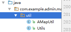
AMapUtil代碼為:
public class AMapUtil {
    /**
     * 判斷edittext是否null
     */
    public static String checkEditText(EditText editText) {
        if (editText != null && editText.getText() != null
                && !(editText.getText().toString().trim().equals(""))) {
            return editText.getText().toString().trim();
        } else {
            return "";
        }
    }

    public static Spanned stringToSpan(String src) {
        return src == null ? null : Html.fromHtml(src.replace("\n", "<br />"));
    }

    public static String colorFont(String src, String color) {
        StringBuffer strBuf = new StringBuffer();

        strBuf.append("<font color=").append(color).append(">").append(src)
                .append("</font>");
        return strBuf.toString();
    }

    public static String makeHtmlNewLine() {
        return "<br />";
    }

    public static String makeHtmlSpace(int number) {
        final String space = " ";
        StringBuilder result = new StringBuilder();
        for (int i = 0; i < number; i++) {
            result.append(space);
        }
        return result.toString();
    }

    public static String getFriendlyLength(int lenMeter) {
        if (lenMeter > 10000) // 10 km
        {
            int dis = lenMeter / 1000;
            return dis + "";
        }

        if (lenMeter > 1000) {
            float dis = (float) lenMeter / 1000;
            DecimalFormat fnum = new DecimalFormat("##0.0");
            String dstr = fnum.format(dis);
            return dstr;
        }

        if (lenMeter > 100) {
            int dis = lenMeter / 50 * 50;
            return dis + "";
        }

        int dis = lenMeter / 10 * 10;
        if (dis == 0) {
            dis = 10;
        }

        return dis + "";
    }

    public static boolean IsEmptyOrNullString(String s) {
        return (s == null) || (s.trim().length() == 0);
    }

    /**
     * 把LatLng對象轉化為LatLonPoint對象
     */
    public static LatLonPoint convertToLatLonPoint(LatLng latlon) {
        return new LatLonPoint(latlon.latitude, latlon.longitude);
    }

    /**
     * 把LatLonPoint對象轉化為LatLon對象
     */
    public static LatLng convertToLatLng(LatLonPoint latLonPoint) {
        return new LatLng(latLonPoint.getLatitude(), latLonPoint.getLongitude());
    }

    /**
     * 把集合體的LatLonPoint轉化為集合體的LatLng
     */
    public static ArrayList<LatLng> convertArrList(List<LatLonPoint> shapes) {
        ArrayList<LatLng> lineShapes = new ArrayList<LatLng>();
        for (LatLonPoint point : shapes) {
            LatLng latLngTemp = AMapUtil.convertToLatLng(point);
            lineShapes.add(latLngTemp);
        }
        return lineShapes;
    }

    /**
     * long類型時間格式化
     */
    public static String convertToTime(long time) {
        SimpleDateFormat df = new SimpleDateFormat("yyyy-MM-dd HH:mm:ss");
        Date date = new Date(time);
        return df.format(date);
    }

    public static final String HtmlBlack = "#000000";
    public static final String HtmlGray = "#808080";

    public static String getFriendlyTime(int second) {
        if (second > 3600) {
            int hour = second / 3600;
            int miniate = (second % 3600) / 60;
            return hour + "小時" + miniate + "分鐘";
        }
        if (second >= 60) {
            int miniate = second / 60;
            return miniate + "分鐘";
        }
        return second + "秒";
    }


    public static String getBusPathTitle(BusPath busPath) {
        if (busPath == null) {
            return String.valueOf("");
        }
        List<BusStep> busSetps = busPath.getSteps();
        if (busSetps == null) {
            return String.valueOf("");
        }
        StringBuffer sb = new StringBuffer();
        for (BusStep busStep : busSetps) {
            if (busStep.getBusLines().size() > 0) {
                RouteBusLineItem busline = busStep.getBusLines().get(0);
                if (busline == null) {
                    continue;
                }
                String buslineName = getSimpleBusLineName(busline.getBusLineName());
                sb.append(buslineName);
                sb.append(" > ");
            }
            if (busStep.getRailway() != null) {
                RouteRailwayItem railway = busStep.getRailway();
                sb.append(railway.getTrip() + "(" + railway.getDeparturestop().getName()
                        + " - " + railway.getArrivalstop().getName() + ")");
                sb.append(" > ");
            }
        }
        return sb.substring(0, sb.length() - 3);
    }

    public static String getBusPathDes(BusPath busPath) {
        if (busPath == null) {
            return String.valueOf("");
        }
        long second = busPath.getDuration();
        String time = getFriendlyTime((int) second);
        float subDistance = busPath.getDistance();
        String subDis = getFriendlyLength((int) subDistance);
        float walkDistance = busPath.getWalkDistance();
        String walkDis = getFriendlyLength((int) walkDistance);
        return String.valueOf(time + " | " + subDis + " | 步行" + walkDis);
    }

    public static String getSimpleBusLineName(String busLineName) {
        if (busLineName == null) {
            return String.valueOf("");
        }
        return busLineName.replaceAll("\\(.*?\\)", "");
    }


}
Utils的主代碼為:
public class Utils {


    /**
     * 開始定位
     */
    public final static int MSG_LOCATION_START = 0;
    /**
     * 定位完成
     */
    public final static int MSG_LOCATION_FINISH = 1;
    /**
     * 停止定位
     */

    /**
     * 根據定位結果返回定位信息的字元串
     *
     * @return
     */
    public synchronized static String getLocationStr(AMapLocation location, final int index) {
        if (null == location) {
            return null;
        }
        StringBuffer sb = new StringBuffer();
        //errCode等於0代表定位成功,其他的為定位失敗,具體的可以參照官網定位錯誤碼說明
        if (location.getErrorCode() == 0) {
            sb.append("定位成功" + "\n");
            sb.append("定位類型: " + location.getLocationType() + "\n");
            sb.append("經    度    : " + location.getLongitude() + "\n");
            sb.append("緯    度    : " + location.getLatitude() + "\n");
            sb.append("精    度    : " + location.getAccuracy() + "米" + "\n");
            sb.append("提供者    : " + location.getProvider() + "\n");


            if (location.getProvider().equalsIgnoreCase(
                    android.location.LocationManager.GPS_PROVIDER)) {
                // 以下信息只有提供者是GPS時才會有
                sb.append("速    度    : " + location.getSpeed() + "米/秒" + "\n");
                sb.append("角    度    : " + location.getBearing() + "\n");
                // 獲取當前提供定位服務的衛星個數
                sb.append("星    數    : "
                        + location.getSatellites() + "\n");
            } else {
                // 提供者是GPS時是沒有以下信息的
                sb.append("國    家    : " + location.getCountry() + "\n");
                sb.append("省            : " + location.getProvince() + "\n");
                sb.append("市            : " + location.getCity() + "\n");
                sb.append("城市編碼 : " + location.getCityCode() + "\n");
                sb.append("區            : " + location.getDistrict() + "\n");
                sb.append("區域 碼   : " + location.getAdCode() + "\n");
                sb.append("地    址    : " + location.getAddress() + "\n");
                sb.append("興趣點    : " + location.getPoiName() + "\n");
                return (location.getAddress() + "," + location.getLongitude() + "," + location.getLatitude());
            }
//這個方法可以進行反向的地理圍欄圈定
  //if(location.getLatitude()==“緯度”||location.getLongitude()==“經度”){
            //    sb.append("可以簽到"+"\n");
              //  return sb.toString();

          //  }
          //  else {
           //     sb.append("不可簽到"+"\n");

        //    }

    //    }

        else {
            //定位失敗
            sb.append("定位失敗" + "\n");
            sb.append("錯誤碼:" + location.getErrorCode() + "\n");
            sb.append("錯誤信息:" + location.getErrorInfo() + "\n");
            sb.append("錯誤描述:" + location.getLocationDetail() + "\n");
            return sb.toString();
        }
        return sb.toString();

    }


}
如果要使用那個逆地理的編碼圍欄,你需要自己設定button控制項的響應事件,通過返回值來控制button是否開啟